SUCCESS!!!
THANK YOU TO ALL WHO HELPED!…BUT IT DOESN’T STOP HERE. THE EVENT DOESN’T HAVE TO HAPPEN FOR US TO TAKE STEWARDSHIP OF OUR RIVERS!
ANYTIME YOU’RE OUT ON THE WATER, WE ENCOURAGE YOU TO TAKE SOME MEMORIES AND TRASH WITH YOU!
————————————————————————————————
2020 Animas River and Trail Cleanup -
Due to COVID, we are foregoing our one day group get together for the cleanup of the Animas River and Trail. Instead, we are targeting the entire month of October and using a model that allows you to select the day and reach of your choice.
Those wanting to participate can register below. Please indicate your date as well as your chosen section of river in the message section (e.g., 5-RL). Reach descriptions are detailed below.
The large plastic garbage bags to be used are available for pick-up at the Recreation Center. Go to the front desk and mention that you are participating in the 5 Rivers Trout Unlimited Animas River cleanup.
Once you have completed the cleanup of the selected reach, leave the debris/bags on the side of the River Trail, but not on the trail itself. Take a picture of the debris/bag, note the location on the trail where the debris/bags were left and the name of the reach that was cleaned and text to the cleanup organizer at 970-759-2726. She/he will advise the City staff where to collect the debris/bags. In the event enough debris is found to warrant multiple drops along the trail, please advise the organizer of the location of the drops.
Safety is paramount! Participants are encouraged to wear sturdy gloves (not latex, unless worn under sturdy gloves). Participants are advised to NOT pick up any medical waste, including syringes.
Finally, we will award prizes for the following categories so text us your pictures.
Most trash
Grossest trash
Oldest trash
Heaviest trash
REGISTRATION FORM
REACHES
The Reaches are defined by the upstream to downstream points and as either River Right (RR) or River Left (RL). The side of the River that is either right or left is identified as that side of the river when facing downstream.
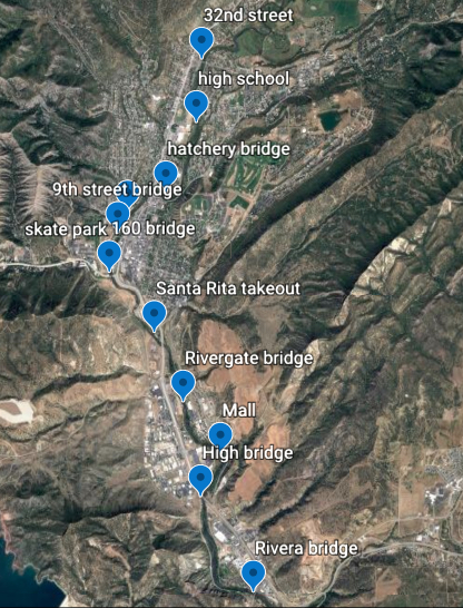
Click to open the map.
1-RL 32nd St to High School Bridge - River Left
1-RR 32nd St to High School Bridge - River Right
2-RL High School Bridge to Hatchery Bridge - River Left
2-RR High School Bridge to Hatchery Bridge - River Right (Carl Darnell)
3-RL Hatchery Bridge to Skate Park Bridge - River Left (Cub Scout Pack 502)
3-RR Upstream end of Skate Park to Skate Park Bridge - River Right
4-RL Skate Park Bridge to 9th St. Bridge - River Left (Doug Braam-Expedition Outside)
4-RR Skate Park Bridge to 9th St. Bridge - River Right
5-RL 9th St. Bridge to Hwy 160 Bridge-River Left (Doug Braam-Expedition Outside)
5-RR 9th St. Bridge to Hwy 160 Bridge-River Right
6-RL Hwy 160 Bridge to Santa Rita Park raft take out - River Left
6-RR Hwy 160 Bridge to Santa Rita Park raft take out - River Right (Dog Park)
7-RL Santa Rita raft takeout to Rivergate Bridge - River Left
7-RR Santa Rita raft takeout to Rivergate Bridge - River Right (Sam Lewarchick)
8-RL Rivergate Bridge for 100 yards downstream (beyond is private property) - River Left
8-RR Rivergate Bridge to the Mall - River Right
9-RL Mall to the High Bridge - River Left (This reach is just along Hwy 3)
9-RR Mall to the High Bridge - River Right
10-RL High Bridge to Rivera Bridge - River Left
10-RR High Bridge to Rivera Bridge - River Right